
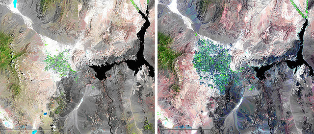
 Landsat view of Las Vegas & Lake Mead ©V-rider
Vagabondish is reader-supported. When you buy through links on our site, we may earn a small affiliate commission. Read our disclosure.
Just in time to celebrate the Landsat 5’s 28th birthday, NASA and the U.S. Geological Survey released an interesting time-lapse video chronicling the growth of Las Vegas from 1972 to 2010.
The Landsat program is the longest running project acquiring satellite imagery of Earth. Over the years, the instruments on Landsat satellites have taken millions of images.
The images used in the time lapse were taken using the Landsat 5 satellite. The false color was added to the images to make the differences from year-to-year more obvious to the untrained eye.
The Landsat program is still going strong and the next satellite addition, Landsat 8, is scheduled to launch in January 2013.
Watch the video at YouTube.