
© Powerhousemuseum.com
Vagabondish is reader-supported. When you buy through links on our site, we may earn a small affiliate commission. Read our disclosure.
Creating Augmented Reality (AR) applications, programs that take the images fed into your phone by camera and overlay them with digital information, sounds insanely futurist. At least in theory though – in theory – the process should be relatively straightforward: your phone has a GPS that knows where you are and a compass that knows which direction you’re facing. Given a basic layout of your immediate area the cameraphone can even try to “snap” to the landscape. There’s even an open platform called Layar, available for Android and iPhone, that automates much of the process.
The hard part is compiling the raw data, the stuff that makes a project interesting, that gives flesh to the digital skeleton. That’s where the hard choices begin: where will the AR apply, what are you going to put in the layer, and – most pointedly – how are you going to compile the information? Preparing the data, which involves the irreducibly physical work of selecting and tagging and uploading, is always the most grinding part of these kinds of projects. Not coincidentally it’s also when they tend to fall apart.
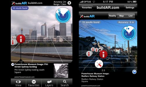
Sydney’s Powerhouse Museum’s new app, built on Layar, allows people to walk around and view historical Sydney on an AR layer. If you orient your phone on a landmark the app will provide all kinds of information, from what it looked like historically to locations on Flickr and Powerhouse’s site that have more information. That last part also gives a hint as to how they built the application.
For the EU’s AR tourism project project, the bulk of their effort went into compiling the historical data. It just didn’t exist, or at least not in any usable form. That’s what took them years to create. Luckily for this application’s builders there was already a gigantic database waiting to be fed into the right program: the Powerhouse Museum’s 400 images of geotagged Flickr images. They had already gone through most of the grinding effort. Get Flickr talking to the phone and all that was left wass building the application itself – again, not trivial, but certainly not the most daunting part.
Expect to see hundreds of applications popping up in the next few years that take exactly this approach: using publicly licensed geotagged data and widely available software platforms to mash up their own AR layers. The things we can do…